Frequently asked questions
Using Safeswim
Safeswim helps you decide if it is OK to go for a swim at your favourite swimming spot.
Safeswim tells you when the water quality is good or if there is an increased risk of getting sick (e.g., due to a wastewater overflow).
Safeswim also tells you when lifeguards are on patrol and when there are hazardous conditions that may make swimming dangerous.
You can also find the weather forecast for each beach and when it will be high or low tide.
Safeswim aims to provide as near to real-time information as possible so you always have the latest information on current and forecast conditions.
Checking Safeswim before you head out helps you avoid unnecessary health risks and dangerous situations.
Pollution from stormwater runoff, wastewater networks, and other sources can make the water quality at beaches and in lakes and rivers unfit for swimming.
Hazards such as rips, large waves, strong winds and sharks can make swimming dangerous. Other hazards such as jellyfish and algal blooms can be harmful to your health.
Remember, water quality and conditions can change quickly and are not always obvious from the shore.
You can find out what Safeswim’s pins and symbols mean by clicking here.
Water quality can change quickly. Water quality is often worst during and after heavy rain because rain washes pollution into waterways and can trigger wastewater overflows. Safeswim helps you avoid higher-than-normal risk by warning you when conditions are worse than usual.
Not all beaches are the same. The water quality at each beach may vary depending on local currents and tides, discharges from streams, stormwater outlets or wastewater overflows, and the type of land use around the beach.
Safeswim’s water quality information is calibrated to each individual beach. This means that beaches next to each may have different colour pins at the same time.
The risks of swimming at the beach
A variety of hazards may be present at beaches and freshwater swimming spots.
Safeswim’s Beach Safety page tells you about the most common hazards to watch out for as well as tips on how to stay safe in the water.
You can also find out what the hazards are at each location by clicking on the Beach Status and Beach Info tabs when viewing any site on Safeswim.
Jumping into the water is a fun and popular activity during the New Zealand summer. But it is also dangerous. Each year in New Zealand hundreds of people are injured jumping off wharves or other structures. Injuries range from scrapes and bruises to shattered bones, damaged spines or even death.
Never jump into the water with knowing what is under the water and how deep it is.
See Safeswim’s Beach Safety page for more guidance on avoiding injury when jumping.

If a green pin is showing on Safeswim then the risk of getting sick from swimming is less than 2%. This means that, on average, around 2 out every 100 swimmers might get sick after swimming. In most cases, the likelihood of getting sick will be a lot less than this.

If a red pin is showing on Safeswim then the risk may be much higher than 2% due to contamination caused by stormwater or overflows. This means you have a much higher chance of getting sick if you swim when a red pin is showing.

Long-term alerts are used at locations where water sampling shows that water quality consistently exceeds national guideline values for swimming and cannot be accurately modelled. Where a permanent red pin (long-term alert) is showing, the risk of illness from swimming is estimated to be more than 10%.

The black water quality pin on Safeswim indicates that the beach has been affected by a wastewater overflow. While the risk of illness cannot be reliably estimated, Auckland Council and Watercare strongly advise against swimming in locations where a black pin is showing as untreated wastewater is present.
Safeswim’s advice is based on swimming where you are in direct contact with the water with a high probability of being fully immersed and swallowing water. This includes swimming, surfing, water skiing, and diving.
Activities with less water contact usually carry lower risk, but illness is still possible if you fall in or ingest water. This includes paddling, wading, boating, sailing, and fishing.
No. Water in urban streams and stormwater outlets is generally unsuitable for swimming due to contamination from stormwater runoff and wastewater overflows.
So don't play, paddle, or swim in stormwater pipes and stormwater outlets on the beach, as the water from these outlets is likely to be contaminated even if it looks clean.
Avoid contact with streams during heavy rain and for 48 hours after it stops raining and never drink stream water.
Find out more
Stormwater and the ‘first flush’: Andrew Chin, Head of Strategic Initiatives from Auckland Council’s Healthy Waters and Flood Resilience Department explains…
Swimming in contaminated water can cause:
- Stomach bugs (vomiting, diarrhoea)
- Ear and eye infections
- Skin rashes
- Respiratory illness
Most illnesses are mild, but some can be serious. If you become unwell within a few days of swimming:
- Contact your GP, or
- Call Healthline on 0800 611 116
If symptoms are severe, seek medical attention urgently.
You should not eat shellfish gathered from urban areas – even from beaches with green pins. This is because shellfish can pick up and store bacteria, viruses, biotoxins, or pollution that can cause sickness. Shellfish on urban beaches may be harmful to eat even if the current water quality is good.
For more information, visit:
Cyanobacteria are microscopic organisms that are naturally occurring and live in lakes and rivers. Cyanobacteria often thrive during the summer months resulting in algal blooms that are bright green in colour and look like pea soup. As cyanobacteria can produce toxins that are harmful to animals and humans, contact with water affected by algal blooms is not advised.
If someone in the water is in trouble dial 111 and ask for the Police. Information on who to contact to report emergencies, pollution, or other issues is provided in the Contact section under About Safeswim.
How Safeswim works
- Weather: Safeswim's weather descriptions are retrieved from the forecasts on AccuWeather corresponding to the location of the site.
- Wind: Wind speed forecasts for each Safeswim site are based on data retrieved from the Numerical Weather Prediction (NWP) global model.
- Tides: The tide data for Safeswim is sourced from the National Institute of Water and Atmospheric Research (NIWA).
- Water temperatures: MetOcean Solutions' oceanographic and atmospheric forecast models are used to obtain sea temperature predictions at each Safeswim site. There are always local variations in water temperature related to beach shape, water depths, and local weather patterns (e.g., sunlight or wind) that may influence the temperature in any particular location.
Safeswim’s water quality forecasts and alerts come from a combination of:
• Regular water quality sampling
• Real-time rainfall, tide, wind, and sunlight data
• Computer models that predict risk
• Live detection of wastewater overflows from sensors on the wastewater network
• Manual alerting of other conditions causing a public health risk (e.g., algal blooms or un-monitored wastewater discharges)
Safeswim’s water quality information is updated every 15 minutes.
Sampling alone cannot provide timely public advice because water quality can change faster than samples can be collected and analysed. Water quality samples are usually taken weekly and take up to 48 hours to analyse. This means that a sample test result indicates what water quality conditions were like anywhere from 2 to 9 days ago. The current water quality may be quite different, especially if it has been raining or a wastewater overflow has occurred.
Safeswim uses predictive modelling and live alerting of wastewater overflows to update information on current water quality conditions every 15 minutes. However, ongoing sampling is essential to ensure Safeswim’s predictions remain reliable. Safeswim continues to undertake regular and targeted water quality sampling year-round and during different rainfall conditions to build, check, and improve its water quality models.
The black water quality pin on Safeswim indicates that the beach has been affected by a wastewater overflow.
Auckland Council works with Watercare Services Ltd to integrate overflow sensors on the wastewater network into the Safeswim system. When a sensor detects an overflow in progress the Safeswim system automatically overrides the model results at the associated beach with a temporary black pin for 48 hours.
A black pin may also be generated manually if wastewater overflows or contamination events are spotted by operational teams or by members of the public.
Yes. Safeswim gives you trustworthy, up-to-date information so you can enjoy the water with confidence.
Safeswim’s models are built on a rigorous programme of water quality sampling and are evaluated against international standards for model accuracy.
The system is checked regularly to make sure it is working as intended. Each summer, Safeswim’s performance is assessed to confirm that it is accurately identifying when water quality poses a higher or lower risk to swimmers.
Safeswim’s approach has been independently reviewed and internationally recognised as good practice for communicating recreational water quality and swimming safety information.
Neither Councils nor Surf Life Saving New Zealand have the authority to close beaches. Safeswim provides information so people can make informed choices.
Physical signage may be erected at beaches where there is a severe or long-term public health risk. However, it is not practical to erect physical signage at every beach for every instance of poor water quality.
Safeswim provides the most up‑to‑date information on water quality conditions online and via the app. Digital Safeswim signs are also present at the following locations in the Auckland region:
- Browns Bay
- Clarks Beach
- Herne Bay
- Judges Bay
- Maraetai Beach
- Mission Bay
- Orewa
- St Marys Bay
- Takapuna Beach
- Taumanu
- Ōmaru (Formerly Point England Reserve)
For those who want more detail
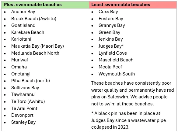
Each year, beaches are ranked according to the percentage of time that they were suitable for swimming over summer.
Safeswim’s best and worst beaches (Auckland, 2025/26)
Poor water quality that can make people sick is usually caused by faecal contamination (poo) from people or animals entering the water.
This contamination can come from:
- Animal faeces being washed into streams, rivers, and beaches after rain
- Wastewater overflows
- Household wastewater pipes being incorrectly connected to the stormwater network
- Leaks from private septic systems
- Wild and domestic animals
The risk of contamination is generally higher:
- During and after rain
- Near stormwater outlets and urban streams
- In older urban areas with combined stormwater and wastewater systems
- In areas relying on septic systems
Find out more
Stormwater and the ‘first flush’: Andrew Chin, Head of Strategic Initiatives from Auckland Council’s Healthy Waters and Flood Resilience Department explains…
Across New Zealand, councils and water utilities are working to reduce pollution and improve water quality.
In Auckland, this includes:
- Investing in stormwater upgrades through the Water Quality Targeted Rate. Find out more here.
- Finding and fixing wastewater entering stormwater networks (Safe Networks programme). Find out more here.
- Reducing wet-weather wastewater overflows (Watercare’s inflow and infiltration programme). Find out more here.
- Improving septic system management in rural areas (Safe Septics programme). Find out more here.
- Improving the region's stormwater network and waterways to reduce pollution, prevent contamination, and improve water quality. Find out more here.
These improvements take time, but they are reducing pollution and improving water quality across many locations.
The risk of illness from swimming is associated with levels of micro-organisms in the water, called Faecal Indicator Bacteria (FIB). Faecal indicator bacteria are bacteria that come from the gut of warm-blooded animals (including people). They indicate the presence of faeces (poo) and are associated with the presence of disease-causing pathogens. The two common bacteria that are measured are E. coli, in freshwater, and enterococci, in seawater.
Guideline values for E. coli (freshwater) and enterococci (seawater) are specified in the 2003 Microbiological Water Quality Guidelines for Marine and Freshwater Recreational Areas published by the Ministry for the Environment and Ministry of Health and have been selected to keep the risk of illness from swimming at less than 2%. A 2% risk of illness means that, on average, around 1 in 50 people would be likely to become ill after swimming. The swimming guideline is based on the risk of getting sick from being immersed in the water for 10 minutes and putting your head under the water three times.
Safeswim uses computer models to estimate when water quality poses a higher risk to health.
Different beaches use different model types, depending on the information available. In simple terms:
- Some models use rainfall and recent water quality patterns.
- Others use statistical relationships between environmental conditions and contamination.
- The most advanced models simulate how contamination moves and breaks down in the environment.
All models are calibrated to individual locations and are chosen to provide the best possible health advice for that site.
Auckland and Northland Regional Councils have invested in targeted sampling to support the continual development and improvement of predictive water quality models used in Safeswim. Targeted sampling has allowed a gradual transition to more sophisticated models over time.
Find out more:
- How contaminants move in the ocean: Principal Coastal Scientist Ben Tuckey from DHI uses two animations to show how environmental conditions affect the movement of contaminant plumes in the ocean, demonstrating why a beach might be a ‘red alert’ or ‘green alert’ under different circumstances.
- How the Safeswim models work: Principal Coastal Scientist Ben Tuckey from DHI explains how the Safeswim models work, what the Safeswim models allow, how they are built and improved with sampling data, and how we know their predictions are accurate.
Safeswim’s accuracy is checked by comparing the results of water quality sampling with Safeswim’s water quality prediction at the same time and location. Safeswim is considered accurate if Safeswim’s risk prediction – either low risk (green pin) or high risk (red pin) – aligned with the water sampling results.
Accuracy is assessed each year, overseen independently. Safeswim has proven to accurately represent water quality between 85–93% of the time since 2019.
Because Safeswim is designed to protect public health, it may sometimes advise caution even when conditions later turn out to be acceptable.
Safeswim continues to sample many sites that are not yet shown on Safeswim. New locations are added once enough data exists to build and test a reliable model, or water quality is shown to be consistently good or consistently poor.
Until a site is added, it is safest to avoid swimming during and for 24–48 hours after heavy rain.
Safeswim does not provide water quality forecasts for swimming locations outside the Auckland and Northland regions. Please contact your regional council for water quality information.
Safeswim uses tide forecasts from NIWA’s official, location-specific models.
The NIWA Tide Forecaster uses a computer tide model to provide the tide levels at each beach location. For most coastal locations the forecasts of high and low tides will be accurate within 5-15 minutes in time.
Some other websites:
- Use distant reference points
- Apply simple time offsets
- Rely on older or simplified data
In complex harbours, this can lead to large differences. Safeswim uses NIWA’s forecasts because they are tailored to each location and regularly updated.